
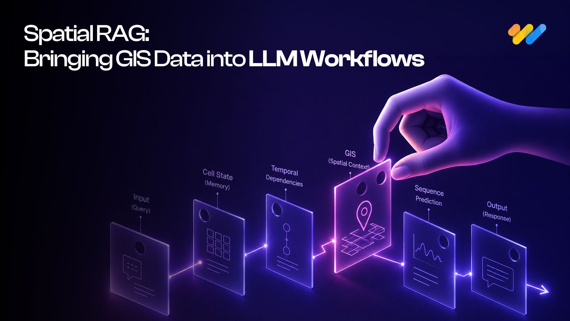

Spatial RAG: The Missing Layer Between GIS Data and LLMs
Ask an LLM which substations are inside a flood zone, and it may answer confidently without performing a spatial query. It can read the documents but cannot reliably verify distance, containment or intersection. That gap is exactly what Spatial RAG is designed to solve.
Yet many LLM workflows still treat GIS data as ordinary text. A service boundary, pipeline route or land parcel can lose its meaning when the geometry behind it is not available to the retrieval system. Spatial RAG addresses this gap by bringing GIS data, spatial indexes, geometries and location-aware retrieval into LLM workflows, allowing AI systems to answer geospatial questions with verified spatial context and clearer reasoning.
What Is Spatial RAG?
Spatial RAG is a retrieval-augmented generation architecture that connects language-based retrieval with geospatial retrieval. It allows large language models to work with GIS data, spatial relationships and location-specific context instead of relying only on text-based documents.
In a standard RAG workflow, a user asks a question, the system retrieves relevant text chunks from a knowledge base and the LLM generates an answer using that retrieved context. Spatial RAG adds a geospatial layer to this process. The system can retrieve GIS features, geometry metadata, nearby assets, spatial joins, map layers, satellite-derived attributes, field notes and location-linked records. It can also apply spatial filters such as bounding boxes, distance ranges, polygons, routes and administrative boundaries.
For example, a user may ask, “Which substations are within 2 km of flood-prone areas and have open maintenance issues?” A normal RAG system may search for documents that mention substations, floods and maintenance. A Spatial RAG system can identify the flood polygon, find substations within a 2 km buffer, connect those assets with maintenance tickets and send the verified results to the LLM for explanation.
The key shift is simple: retrieval happens through both language and location.
Why LLMs Are Spatially Illiterate
LLMs are strong at language, summarization and pattern recognition, but they are not reliable spatial engines by default. A model may know that Chicago and Milwaukee are nearby cities, yet fail to calculate the correct driving distance between them. It may also describe a property as being near an interstate without checking the actual parcel location.
This happens because plain text does not preserve the coordinates, boundaries, distances and relationships stored in GIS data. Spatial meaning depends on geometry and verified location-based calculations, not just the words attached to a place or asset.
Spatial RAG separates these responsibilities. The GIS engine handles containment, intersection, distance, routing and adjacency, while the LLM receives the verified results and turns them into a clear explanation, recommendation or field-ready answer.
This allows organizations to combine the accuracy of GIS analysis with the accessibility of natural-language AI.
The Spatial RAG Architecture
Spatial RAG is not a single retrieval step. It must coordinate geospatial data, spatial computation and language-based search while keeping verified geometry separate from generated explanations.
A practical architecture therefore consists of five layers: geospatial data, spatial processing, embedding and indexing, hybrid retrieval and LLM response.
The first layer is geospatial data. It includes assets, parcels, boundaries, roads, utilities, inspections, work orders and field notes stored in formats such as GeoJSON, Shapefiles, GeoPackages, PostGIS or GeoParquet.
The second layer is spatial processing. Here, geometries are cleaned, coordinate reference systems are validated and operations such as buffering, distance calculation and spatial joins are prepared using tools such as PostGIS, GDAL, GeoPandas or QGIS.
The third layer is embedding and indexing. Descriptions, inspection notes and maintenance records are embedded for semantic search, while the actual geometry is stored separately for reliable spatial filtering.
The fourth layer is hybrid retrieval. It combines semantic search with spatial queries, metadata and time-based filters. For example, a query about flood-vulnerable transformers may retrieve relevant asset records and then verify which ones fall within 500 metres of a flood zone.
In the final layer, the LLM receives filtered and spatially verified context. It converts those results into a clear answer with citations, map references, assumptions and limitations.
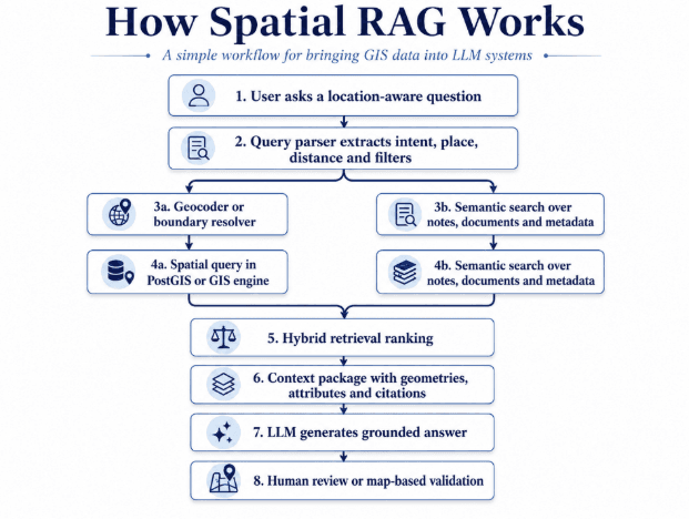
Once these layers are in place, the retrieval pattern becomes easier to understand at the database level.
Code-Level Pattern: PostGIS Plus Vector Search
Spatial RAG becomes useful when semantic retrieval and spatial filtering work together. A vector search can find records that match the meaning of a query, while a spatial query can verify whether those records meet location-based conditions.
A simplified PostGIS plus pgvector pattern may look like this:
SELECT a.asset_id, a.asset_type, a.name, a.status, ST_Distance(a.geom::geography, f.geom::geography) AS distance_meters, a.description FROM assets JOIN flood_zones f ON ST_DWithin(a.geom::geography, f.geom::geography, 500) WHERE a.asset_type = 'transformer' ORDER BY a.embedding <-> :query_embedding LIMIT 10;
This query finds transformer assets within 500 meters of flood zones, calculates the actual distance and ranks the results using semantic similarity. The spatial condition ensures that the retrieved assets are physically relevant. The vector ranking ensures that the returned records also match the user’s intent.
This is the core pattern behind Spatial RAG. A standard vector search may retrieve assets with descriptions related to flood risk, but it may include records outside the relevant geography. A spatial query may return nearby assets, but it may miss operational intent. By combining both, the system can retrieve records that are contextually useful and spatially valid.
For production systems, this pattern usually requires geometry indexes such as GIST or SP-GIST, vector indexes such as HNSW or IVFFlat, metadata filters for asset type and region, CRS validation before distance calculations and a reranking step that balances semantic score with spatial relevance.
The final result should not be sent to the LLM as raw database output. It should be converted into a compact context package that includes asset IDs, distances, geometry references, relevant attributes and source citations.
Three Practical Spatial RAG Examples
1. Asset Queries for Utilities
A utility company may ask, “Which underground cables near the river have unresolved inspection issues?” A Spatial RAG workflow can resolve the river boundary, create a 250-meter buffer, find cable assets within that area and connect them with inspection records, field notes and maintenance tickets. The final answer can highlight the number of affected cables, unresolved issues, high-priority risks and recommended field actions.
2. Site Selection
A logistics team may ask, “Find possible warehouse sites within 5 km of a highway, outside flood zones and near industrial labour clusters.” Spatial RAG can combine parcel polygons, road networks, flood zones, zoning data, labour density layers and internal site evaluation notes. The GIS layer narrows the options, while the LLM explains the shortlist in plain language.
3. Field Q&A
A technician may ask, “What should I check on this pump station before closing the ticket?” The system can use GPS location to identify the nearest asset, retrieve maintenance history, inspection checklists, connected infrastructure and site-specific safety notes. The response can guide the technician without requiring manual searches across GIS layers, PDFs or work order systems.
Data Readiness Requirements
Spatial RAG is only as reliable as the GIS data behind it. Before deployment, teams need to check whether their spatial data is accurate, consistent, current and ready for retrieval.
Geometry quality comes first. Invalid polygons, duplicate features, broken lines and missing coordinates can lead to wrong results. CRS consistency is equally important because distance calculations can become misleading when layers use different coordinate reference systems. Spatial RAG systems should transform layers before spatial queries and preserve CRS metadata.
Metadata completeness also affects answer quality. A geometry without useful attributes is difficult for an LLM to explain, so asset type, ownership, inspection status and operational notes should be available. Temporal freshness matters because roads open, assets move, sites get rezoned and flood maps change.
Access control should also be built into retrieval because location data can be sensitive. For planning, safety, emergency response and compliance, the LLM should explain retrieved results and show evidence, but human validation should remain part of the workflow.
Limits of Spatial RAG Today
Spatial RAG is useful, but teams should understand its current limits before using it in production workflows.
1. Poor GIS Data Quality
Poor GIS data still leads to poor answers. If boundaries are outdated, assets are incorrectly mapped or metadata is incomplete, the generated response will still be flawed.
2. Coordinate Transformation Errors
Spatial datasets often use different coordinate reference systems, units and projections. If layers are compared without proper transformation, distances may be inaccurate, features may appear misaligned and containment or intersection results may be wrong.
3. Overconfident LLM Responses
LLMs can over-explain weak evidence. A model may produce a confident recommendation even when the spatial context is incomplete. Retrieval results, assumptions, data sources and map references should therefore remain visible.
4. High Query Costs at Scale
Large rasters, high-resolution polygons and real-time IoT streams can make spatial queries expensive. Production systems may require precomputation, tiling, caching or specialized geospatial infrastructure.
5. Emerging Geometry Embeddings
Geometry embeddings are still evolving. For most enterprise use cases, it is safer to embed descriptions and metadata while preserving actual geometry for deterministic GIS queries.
6. Sensitive Location Data
Access control is critical. Restricted asset locations should not become retrievable simply because a semantic query matches.
Spatial RAG works best as a natural-language access layer for verified GIS intelligence, not as a replacement for geospatial systems.
Conclusion
Spatial RAG matters because many enterprise decisions depend on location, context and evidence. Asset planning, field operations, site selection, compliance checks and infrastructure monitoring all require systems that can understand where things are, how they relate to nearby features and what constraints affect the decision.
The strongest workflows will combine GIS reliability with LLM usability. PostGIS, spatial indexes, vector retrieval, metadata filters and prepared GIS data can handle the technical foundation. The LLM can make the result easier to understand, validate and act on.
This is the kind of work where 12th Wonder’s practical experience with enterprise AI, data systems and geospatial workflows becomes useful. The focus is on helping organizations connect spatial data, enterprise systems and AI workflows in a way that is practical, secure and usable in real operations.
Spatial RAG can make geospatial expertise easier to access across teams that depend on location-aware decisions.
FAQ
Want to bring GIS data into AI workflows?
Explore how organizations connect spatial data and AI-powered decision support.