Data Services

Transforming data with precision, our data services offer spatial solutions including network digitization, remote sensing, and LiDAR processing. We ensure accuracy, efficiency, and tailored insights across diverse industries.

Harnessing Diversity in Spatial Data Management

At 12thWonder, we lead the charge in geospatial data services, offering a wide variety of the services that blend cutting-edge technology with a skilled workforce. We offer services including satellite imagery, topographic, thematic maps, spatial analysis, automated mapping (AM), facility management (FM) and geodata solutions.  We provide cost effective solutions with a bunch of in-house products with AI/ML.  

We handle the large-scale projects across telecom, electrical, gas, water, urban, and transportation sectors ensuring accuracy and efficiency.

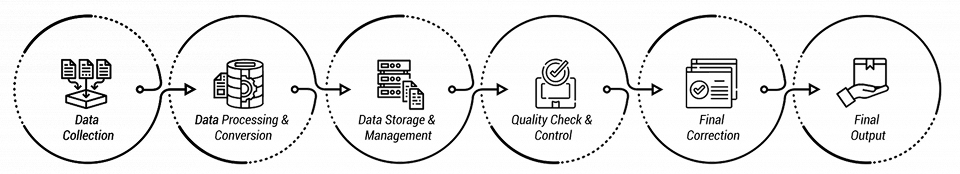
Geospatial Data Services

Network Capturing & Digitization

Transforming Networks on Spatial Platform

We developed an in-house product specifically designed for the seamless data conversion of networks using georeferenced images and scanned maps. The product is extendable, scalable, maintainable, pluggable to make the tailored solutions diversified for industries.

A digital interface showcasing network transformation with maps and georeferenced images.
Digital network infrastructure held on by workers with validation checks ensuring accuracy.

Network improvements & Maintenance

Minimize Network Failure and Maximize Asset Life

We guarantee the accuracy of network data and uphold data integrity, especially when facing incremental changes to the existing network. Our configurable rule-based solutions serve as a robust mechanism to ensure error-free data. These solutions dynamically validate data and its dependencies in real-time, fostering efficiency and optimizations.

Digital network infrastructure held on by workers with validation checks ensuring accuracy.
Work process flowchart of 12th Wonder of data services from Network capturing to Network maintenance.

Data Conflations & Positional Accuracy Improvements

Elevating Geospatial Accuracy to New Heights

The 12thWonder conflating solution automatically aligns the network data based with the help of control points with the land base changes, providing us the confidence value to review the false positives. The product helps in matching the continuously improving the land base positional accuracy.   
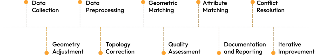
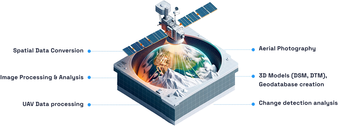
A visual representation of GIS teammates checking on data conflations aligning network data with land base changes.
Visual flowchart of the data conflation process.

Image Services

Remote Sensing

Transforming Earth Observations with Remote Sensing

We are your architects of spatial metamorphosis, blending AI and ML to transform your data landscape. Like skilled cartographers, we guide unstructured data through a seamless journey, crafting structured spatial footprints from high-resolution satellite imagery. With a data model as our compass, we create effective geodatabases, making your data dance in perfect harmony.

Our Remote Sensing area are:

Spatial Data Conversion
Image Processing & Analysis
UAV Data processing
AI-powered data transformation journey from satellite imagery to structured spatial footprints.
Aerial Photography
3D Models (DSM, DTM), Geodatabase creation
Change detection analysis
AI-powered data transformation journey from satellite imagery to structured spatial footprints.
Aerial Photography
3D Models (DSM, DTM), Geodatabase creation
Change detection analysis.
Spatial Data Conversion
Image Processing & Analysis
UAV Data processing

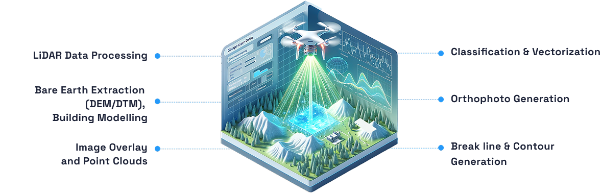
LiDAR Data & Processing Service

Unlocking Precision with LiDAR

We are the maestros of LiDAR, orchestrating topographical data with rapid precision, day or night. Picture us as your digital surveyors, capturing both airborne and terrestrial/mobile LiDAR data with unparalleled quality. We map the heights with clarity, ensuring your landscape is a masterpiece of accuracy. 

Our Mapping Services Span Across:  

LiDAR Data Processing
Bare Earth Extraction (DEM/DTM), Building Modelling
Image Overlay and Point Clouds
LiDAR mapping services creating a detailed, accurate representation of the landscape.
Classification & Vectorization
Orthophoto Generation
Break line & Contour Generation
LiDAR mapping services creating a detailed, accurate representation of the landscape.
LiDAR Data Processing
Bare Earth Extraction (DEM/DTM), Building Modelling
Image Overlay and Point Clouds
Classification & Vectorization
Orthophoto Generation
Break line & Contour Generation

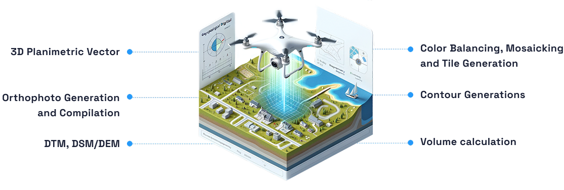
Digital Photogrammetry

Elevate Mapping Accuracy with Photogrammetry

At 12thWonder, we craft precision from aerial snapshots and stereo satellite visions. Our photogrammetric symphony contains Aerial Triangulation, Stereo Images compilation, 3D models like mapping wizards. The solutions are tailor-made and support the precise requirements of the clients across the globe.

 Our expert Imagery and Modeling: 

3D Planimetric Vector
Orthophoto Generation and Compilation
DTM, DSM/DEM
A visual representation of aerial snapshots transforming into precise 3D models and mapping solutions.
Color Balancing, Mosaicking and Tile Generation
Contour Generations
Volume calculation
A visual representation of aerial snapshots transforming into precise 3D models and mapping solutions.
3D Planimetric Vector
Orthophoto Generation and Compilation
DTM, DSM/DEM
Color Balancing, Mosaicking and Tile Generation
Contour Generations
Volume calculation

Quick FAQs

Our processes include rigorous quality assurance measures to ensure accuracy at every stage, from data collection to analysis.

Absolutely. Our robust workforce and advanced technology allow us to adeptly manage large-scale projects in diverse sectors.

We employ AI and image analyses to process drone imagery data, ensuring accurate mapping results and decision making.  

Our geospatial data services encompass a wide range of offerings, including mapping, spatial analysis, data visualization, and custom GIS solutions. We specialize in collecting, processing, and delivering accurate and up-to-date geospatial information tailored to the unique needs of various industries.

We understand the unique needs of each industry and tailor our geospatial services to provide customized solutions that address specific challenges.

Let us be your partner in transforming data into actionable insights.

Reach out now and unlock the potential of your
geospatial data landscape.

Stay Informed

Subscribe to our newsletter for the latest updates
on Geospatial technology.
Subscription icon for staying informed about 12th Wonder's new updates.

Reach Our Team

12thWonder only uses the contact information you provide to contact you about our services. We never share your contact details with others and your information remains confidential within our company. For more information, check out our Privacy Policy