
A real-time geospatial intelligence platform unified fragmented urban mobility data, cut congestion by 25% and transformed how a 10-million-resident Asian metropolis manages movement.
About the Client
A rapidly urbanizing city of over 10 million residents
The client is a large metropolitan smart city initiative in Asia managing urban infrastructure for a population exceeding 10 million. Rapid urbanization, surging vehicle ownership and rising demand for public transit created mounting pressure on traffic systems that were simply not built for this scale. City authorities sought a smarter, more scalable approach one that could match the pace of growth with intelligent, data-driven decision-making.
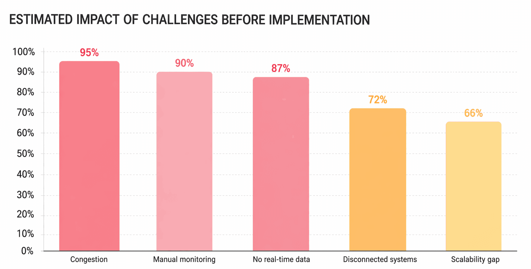
Challenges
| Challenge Area | Root Cause | Business Impact | Severity |
|---|---|---|---|
| Severe traffic congestion on major roads | Rapid urbanization & rising vehicle density | Longer commutes, increased emissions | Critical
|
| Static, manual traffic monitoring | Reliance on fixed-schedule data collection | Inability to respond dynamically to incidents | Critical
|
| No real-time traffic visibility | No IoT or sensor network in place | Congestion hotspots undetected in time | Critical
|
| Disconnected systems | Siloed traffic, transit & emergency data | Poor coordination across city departments | High
|
| Scalability limitations | Legacy infrastructure not designed for growth | No path to handle future population demands | High
|
Solution
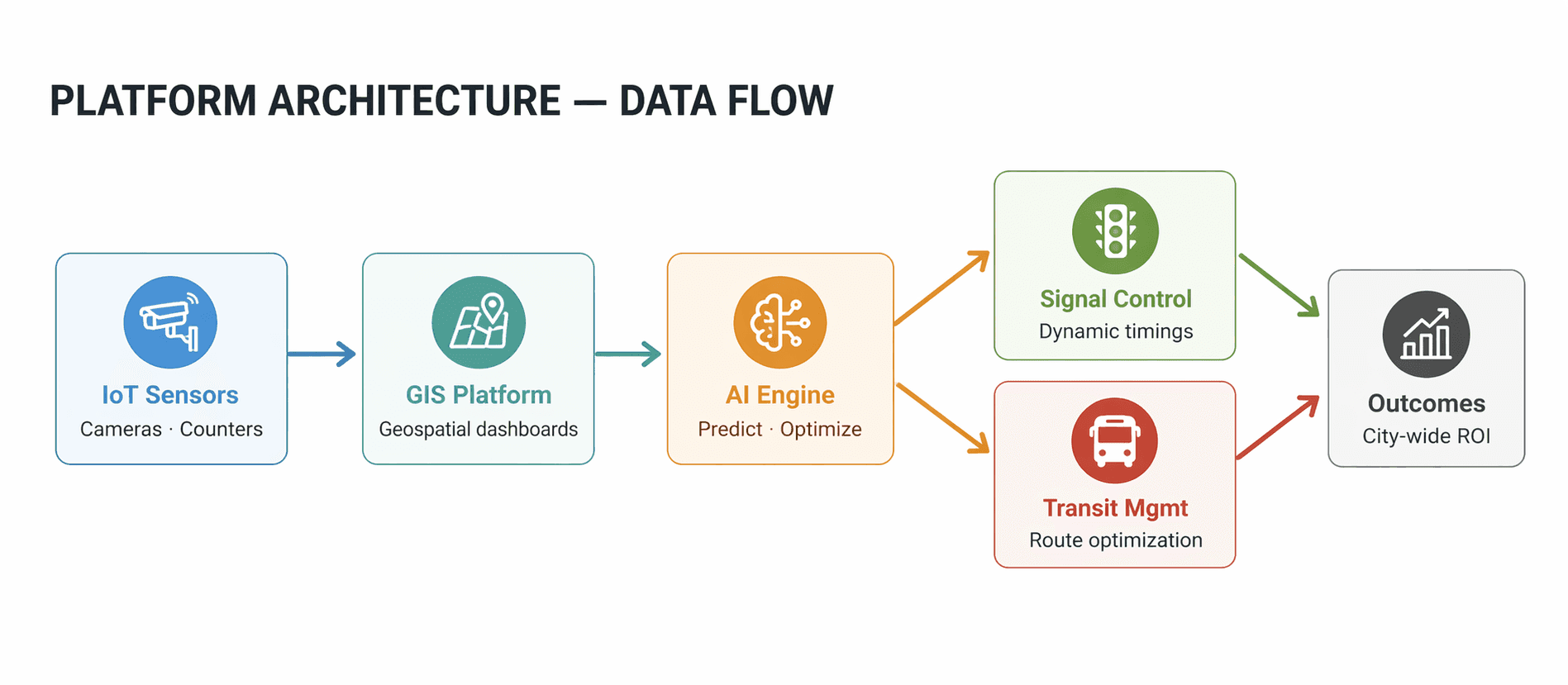
A GIS-AI-IoT platform built for real-time urban intelligence
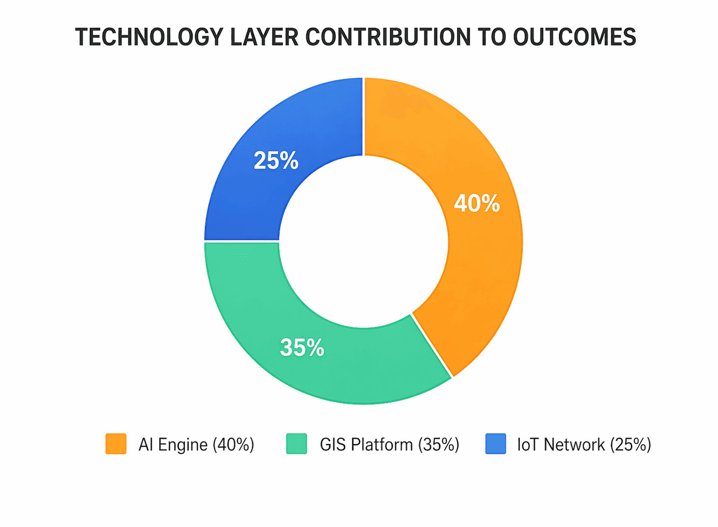
The city implemented a unified GIS-powered traffic management platform integrating IoT sensor networks, AI analytics, and geospatial dashboards. The platform replaced fragmented, reactive processes with a continuous, predictive intelligence loop.
- IoT sensors and smart cameras were deployed across key intersections and road networks to collect real-time traffic data, including vehicle counts, speed, and congestion levels.
- This data was integrated into a centralized GIS platform, where it was visualized through geospatial dashboards.
- AI algorithms analysed traffic patterns and predicted congestion hotspots based on historical and real-time data.
- The platform enabled dynamic traffic signal optimization, adjusting signal timings based on current traffic conditions to improve flow.
- GIS-based dashboards provided city planners with real-time insights into traffic patterns, enabling better decision-making for infrastructure planning and traffic management.
- The system also supported integration with public transportation data, allowing authorities to optimize bus routes and improve transit efficiency.
Key ROI & Business Benefits
Measurable improvement across every mobility metric
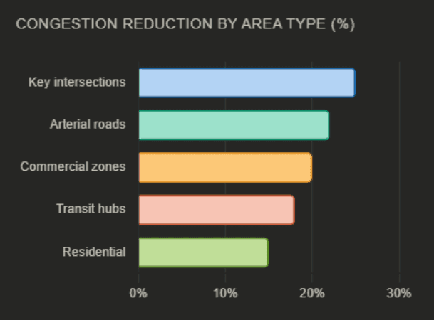
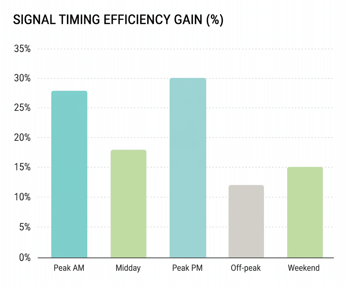
- Traffic flow became more consistent across high-density corridors, reducing peak-hour volatility.
- Signal coordination improved network-wide, easing movement across critical routes and intersections.
- Real-time visibility enabled faster incident detection and response.
- Coordination between traffic control and emergency services became more effective during disruptions.
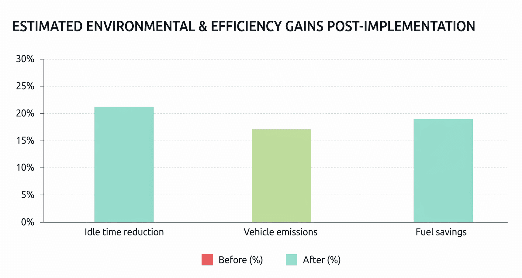
- Lower idle time contributed to reduced fuel consumption and supported sustainability targets.
- Shifted traffic management from static planning to real-time, condition-based operations.
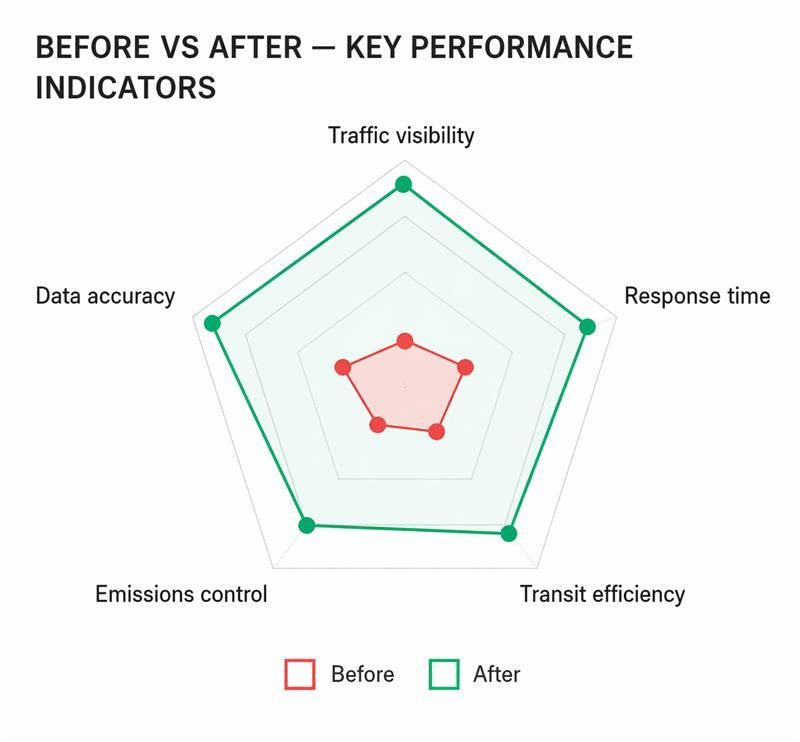
Before vs after platform
From reactive management to predictive intelligence
| Outcome Area | Before Platform | After Platform | Change |
|---|---|---|---|
| Traffic congestion | Severe on major corridors | Reduced across key areas | ↑ 25% |
| Traffic monitoring | Static, manual, periodic | Real-time, automated, continuous | Transformed |
| Congestion detection | Reactive — after incidents | Predictive — before peaks | Proactive |
| Signal optimization | Fixed timing schedules | Dynamic, condition-based | Real-time |
| System coordination | Disconnected silos | Unified GIS platform | Integrated |
| Transit efficiency | No integration with traffic data | Bus routes optimized dynamically | Improved |
| Fuel & emissions | High idle time at signals | Reduced idle, lower emissions | ↓ Emissions |
| Emergency response | Manual coordination, slow | Real-time routing & alerts | Faster |
| Scalability | Legacy, fixed capacity | Cloud-ready, expandable | Future-ready |
By deploying a GIS-AI-IoT traffic management platform, the city established a scalable, intelligent mobility foundation capable of growing with its population. The platform resolved today's congestion along with fundamentally changing how city authorities understand, predict and respond to urban traffic dynamics. This is a replicable model for any smart city seeking to transform mobility through geographic intelligence.
Talk to us about building a predictive traffic management system.
See how this approach can be applied to your organization. Talk to our experts.