
Precision Agriculture Using GIS, AI and IoT for Smart Farming Optimization
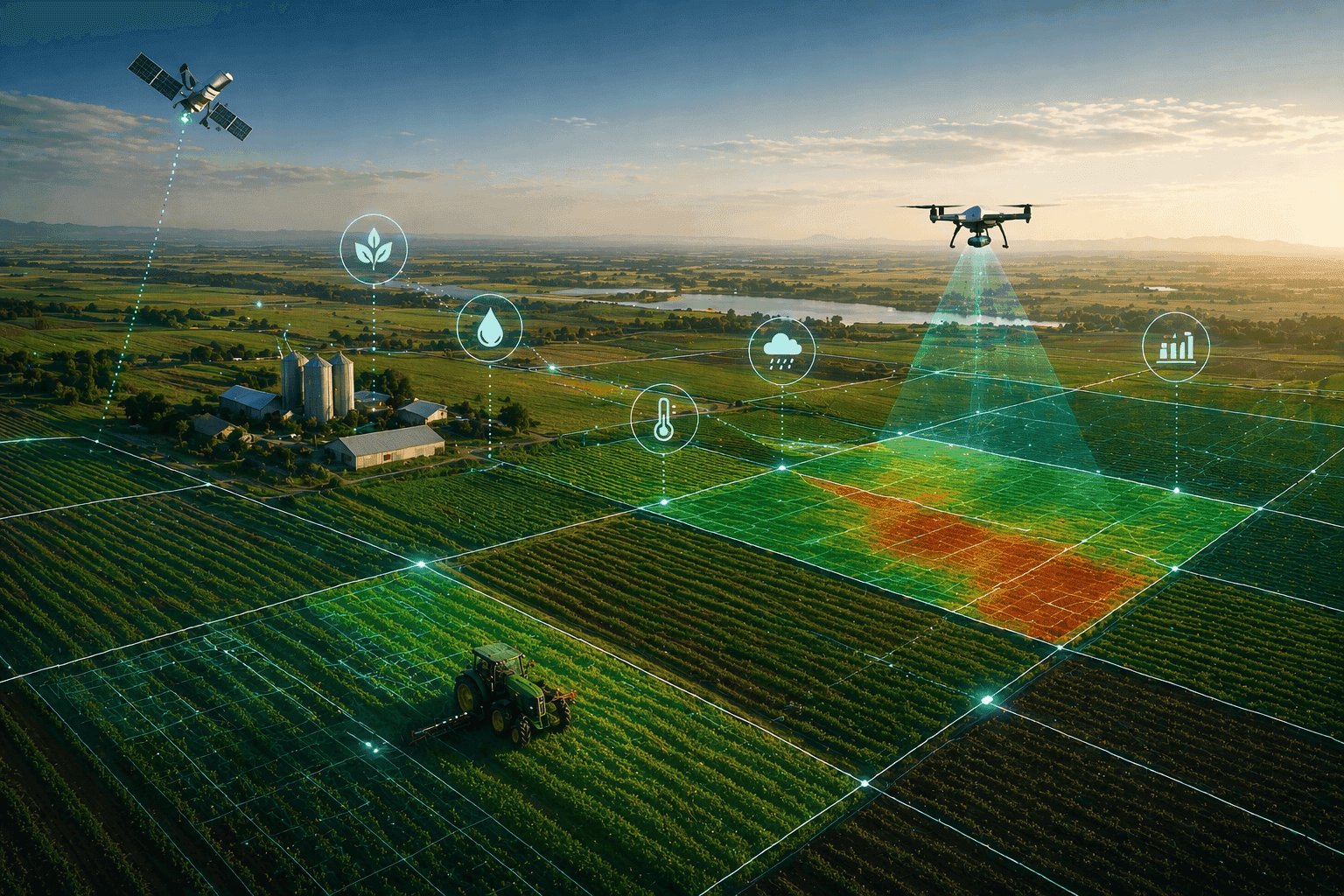
A GIS-powered precision agriculture platform integrated with AI and IoT sensor networks gave large-scale commercial farms across Latin America real-time visibility into crop health, reduced water overuse, and enabled predictive decision-making across tens of thousands of hectares.
| Region | Sector | Scale | Solution |
|---|---|---|---|
| Latin America | Agri-Tech | Tens of thousands of hectares | GIS + AI + IoT Platform |
The Situation
- Large-scale commercial farming across Latin America operates at a scale where manual processes become a structural liability. The company's clients agricultural enterprises managing tens of thousands of hectares of corn, soybean and wheat had built significant farming operations, but the processes behind monitoring and managing those fields had not kept pace with the complexity of what they were running.
- The teams doing the work were experienced and skilled. The problem was lack of infrastructure. Soil moisture readings, temperature logs, nutrient data and irrigation schedules existed as separate, unconnected streams of information. There was no way to correlate what a sensor recorded in one zone with what satellite imagery showed in another and no mechanism to act on that correlation before it became a yield problem.
- The core challenge was visibility or rather, the absence of it. At the scale these farms operated, the gap between knowing something was wrong and knowing it early enough to do anything about it was where yield and revenue were consistently lost.
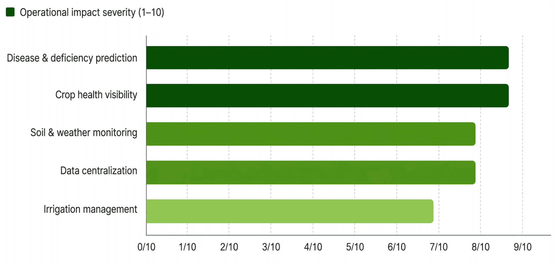
What Was Getting in the Way
The operational friction was real and measurable. Without a centralized platform to aggregate and interpret field data, every decision from adjusting irrigation schedules to flagging early-stage crop disease depended on manual inspections and experienced judgment applied inconsistently across large geographies.
| Challenge Area | Operational Problem | Impact on the Business |
|---|---|---|
| Crop health visibility | No real-time monitoring across large fields; relied on periodic physical inspection | Issues identified too late for effective intervention |
| Soil & weather data | Sensor readings existed in isolation; no central view of moisture, nutrients, or conditions | Incomplete picture led to reactive rather than proactive decisions |
| Irrigation management | Schedules set by experience rather than current soil and forecast data | Excess water consumption; elevated operating costs |
| Disease & deficiency prediction | No predictive capability; outbreaks identified after visible damage appeared | Lost yield and delayed response across affected zones |
| Cross-field decision-making | Each farm unit managed independently without shared data or spatial context | Inconsistent outcomes despite similar conditions |
The GIS-Powered Precision Agriculture Platform
The company implemented a centralized GIS platform that brought together IoT sensor data, satellite imagery and weather inputs into a single operational environment. The goal was to give that expertise a far more complete and timely picture of field conditions.
IoT sensors deployed across the farmland continuously collected readings on soil moisture, temperature, humidity and nutrient levels. This data was ingested into the GIS platform in real time, where it was layered with satellite imagery and weather forecast data to build a composite view of each field zone. AI algorithms then analysed these combined data streams to identify patterns, surface early warning signals and generate actionable recommendations on irrigation, crop health and risk areas. Farmers accessed this through interactive GIS dashboards that displayed geospatial outputs: crop health maps, irrigation zone status and predicted risk areas in a format that matched how they already thought about their land.
| Platform Component | Technology | Function | Cadence |
|---|---|---|---|
| IoT sensor network | Field-deployed sensors | Continuous soil moisture, temperature, humidity, and nutrient readings | Real-time |
| GIS integration layer | Centralized GIS platform | Aggregates sensor data, satellite imagery, and weather feeds into one spatial view | Continuous |
| AI analytics engine | Machine learning models | Analyses data patterns; generates predictive insights for crop health, irrigation and yield | On-demand |
| Crop health maps | Geospatial visualization | Displays NDVI-derived health status by field zone; flags anomalies | Weekly |
| Irrigation automation | Rules-based recommendations | Triggers irrigation guidance based on live soil conditions and forecast data | Real-time |
| GIS dashboards | Interactive BI layer | Unified view of field conditions, risk zones, and operational alerts for farm managers | Live |
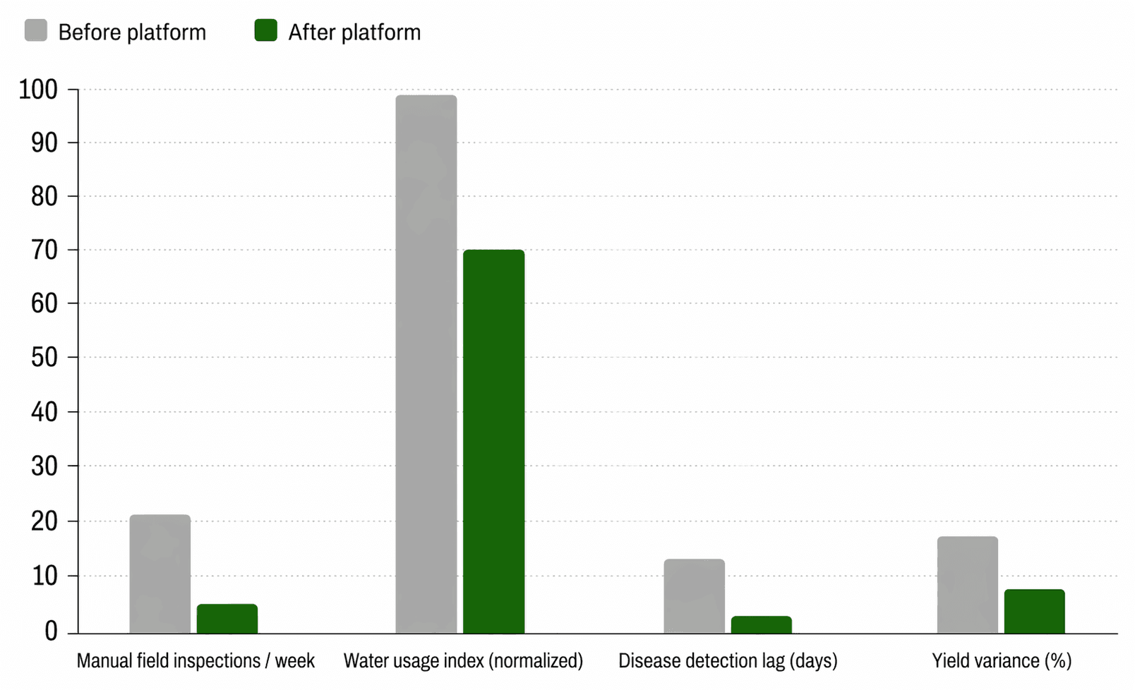
What Changed After Deployment
The shift from disconnected, manual monitoring to an integrated GIS environment had measurable effects on how farms were managed. Decisions that previously took days of inspection and correlation were surfaced in real time. Irrigation schedules moved from experience-based defaults to data-driven recommendations calibrated to actual soil conditions and incoming weather. And crop health issues, previously identified only after visible damage appeared, were flagged early enough for meaningful intervention. The full outcomes summary across dimensions:
| Outcome Area | Before Platform | After Platform | Change |
|---|---|---|---|
| Field health visibility | Periodic manual inspection | Real-time GIS dashboard | Continuous monitoring |
| Irrigation decisions | Experience-based schedules | Sensor + forecast driven | Data-calibrated |
| Disease/deficiency detection | Post-symptom identification | Predictive AI alerts | Early-stage intervention |
| Water consumption | Unoptimized; excess use | Reduced based on soil conditions | ~30% reduction |
| Data environment | Disconnected sensor silos | Unified GIS platform | Single source of truth |
| Decision speed | Days of coordination | Real-time recommendations | Operationally significant |
A More Grounded Approach to Farm Management
Farming at scale will always involve complexity that no platform eliminates entirely. Weather is unpredictable, soil conditions shift and experienced judgment remains essential to how good agricultural decisions get made.
What a well-integrated GIS, AI and IoT platform does is close the gap between what is happening in the field and what a farm manager knows. For this company's clients, that gap had been the source of reactive decisions, wasted resources and yield inconsistency across operations that were otherwise well-run.
The shift to a unified geospatial data environment did not replace what their teams understood about farming. It gave that understanding a real-time foundation to act from. And that changes the quality of every decision that follows.
Let’s map this to your operational challenges. Get a tailored assessment for you.