
Environmental Monitoring and Risk Assessment Using GIS Spatial Services
Client: A government environmental protection agency in North America Industry: Environmental Conservation and Public Sector Region: North America
About the Client
A government environmental protection agency in North America is responsible for monitoring forests, wildlife habitats, water resources and environmental risks across a large geographic region. The agency oversees environmental conservation programs that impact millions of acres of protected land and natural ecosystems. Its core responsibilities include monitoring deforestation, assessing wildfire risks, tracking biodiversity changes and supporting sustainable land-use policies that balance ecological preservation with economic development.
The agency operates at the intersection of science, policy and public accountability. Its work influences decisions that affect communities, industries and ecosystems alike. Accurate, timely environmental intelligence is not simply a technical requirement for the agency. It is a public mandate. As environmental challenges including climate change, accelerating deforestation and increasingly severe natural disasters placed greater pressure on conservation systems, the organization recognized that its existing data infrastructure was no longer sufficient to meet the demands of modern environmental stewardship.
To strengthen its monitoring capabilities and improve decision-making, the agency sought advanced GIS spatial services that could provide deeper, more actionable insights into ecological conditions across its entire jurisdiction.
The Challenge
KEY CHALLENGES BEFORE GIS IMPLEMENTATION
| ||||||
Siloed data systems
Environmental datasets stored in separate systems with no unified spatial framework
|
Limited early detection
Deforestation and wildfire risks were difficult to identify before reaching critical levels
|
Slow manual analysis
Risk assessments required extensive cross-referencing across fragmented data sources
|
No real-time spatial view
Policymakers lacked a live geographic view of ecological conditions and emerging threats
| |||
The agency managed large volumes of environmental data collected from multiple sources including satellite imagery, weather sensors, field surveys and ecological research databases. However, this data was stored across separate systems and lacked a centralized geospatial framework for analysis. Each data source lived in its own environment, managed by different teams using different tools and formats. The result was a fragmented picture of environmental health that made it extremely difficult to draw meaningful conclusions at scale.
Environmental analysts struggled to combine datasets such as rainfall patterns, vegetation coverage, wildfire risk indicators and wildlife migration routes into a unified view. Analysts working on wildfire risk, for example, had to manually cross-reference climate data, vegetation surveys and historical fire records from separate sources before they could begin any meaningful assessment. This process was slow, labor-intensive and prone to inconsistencies.
Monitoring large forest areas was particularly challenging. Environmental teams needed to identify early signs of deforestation, habitat degradation and wildfire risk before these conditions reached a critical threshold. Without spatial analysis tools capable of processing and comparing large-scale imagery datasets, early detection was largely dependent on field teams conducting ground surveys, which were costly and geographically limited.
Without advanced GIS spatial analysis tools, identifying environmental risks and predicting ecological changes required extensive manual analysis that stretched team capacity and delayed response timelines. The agency required a scalable geospatial platform that could integrate its diverse environmental datasets and provide real-time spatial insights for conservation planning and policy development.
The Solution
To support its environmental monitoring initiatives, the agency implemented a GIS spatial services platform designed for environmental analytics and geospatial risk assessment. The platform was built around the principle of data unification. Satellite imagery, climate data, ecological research datasets and field observations were all integrated into a centralized GIS environment, creating for the first time a single authoritative spatial view of the agency's entire jurisdiction.
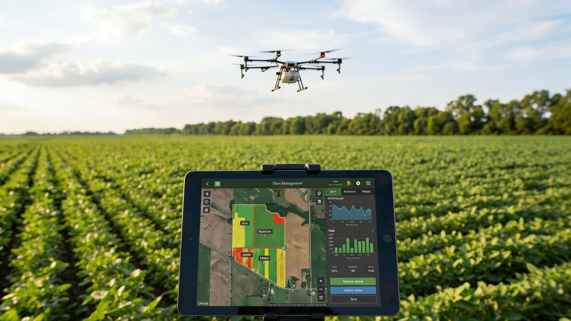
Using spatial analysis tools, environmental analysts were able to visualize environmental indicators across geographic regions and identify patterns that signaled potential risks. Rather than reviewing data from multiple disconnected sources, analysts could now work from a single map-driven interface that surfaced relevant indicators side by side and made spatial relationships immediately visible.
Spatial modeling algorithms were used to analyze vegetation density, soil moisture levels and temperature patterns to predict areas with a higher probability of wildfires. By combining these variables within a spatial model, the platform could generate predictive risk maps that flagged high-risk zones days or weeks before conditions became critical. This gave field teams and emergency planners the lead time needed to mobilize resources and take preventive action.
The platform also enabled analysts to monitor deforestation trends by comparing historical and current satellite imagery datasets. Change detection tools could identify shifts in forest canopy cover, flag unauthorized land clearing and track habitat degradation over time. This capability transformed deforestation monitoring from a reactive audit process into a continuous, proactive surveillance function.
Interactive GIS dashboards provided policymakers with visual insights into environmental conditions across the region, helping them prioritize conservation initiatives and allocate resources more effectively. These dashboards were designed for non-technical users as well as analysts, presenting complex spatial data through intuitive visual layers that could be filtered by geography, risk category, time period and ecosystem type. By leveraging GIS spatial services and geospatial analytics, the agency established a comprehensive, integrated environmental monitoring system built to scale.
Key ROI and Business Benefits
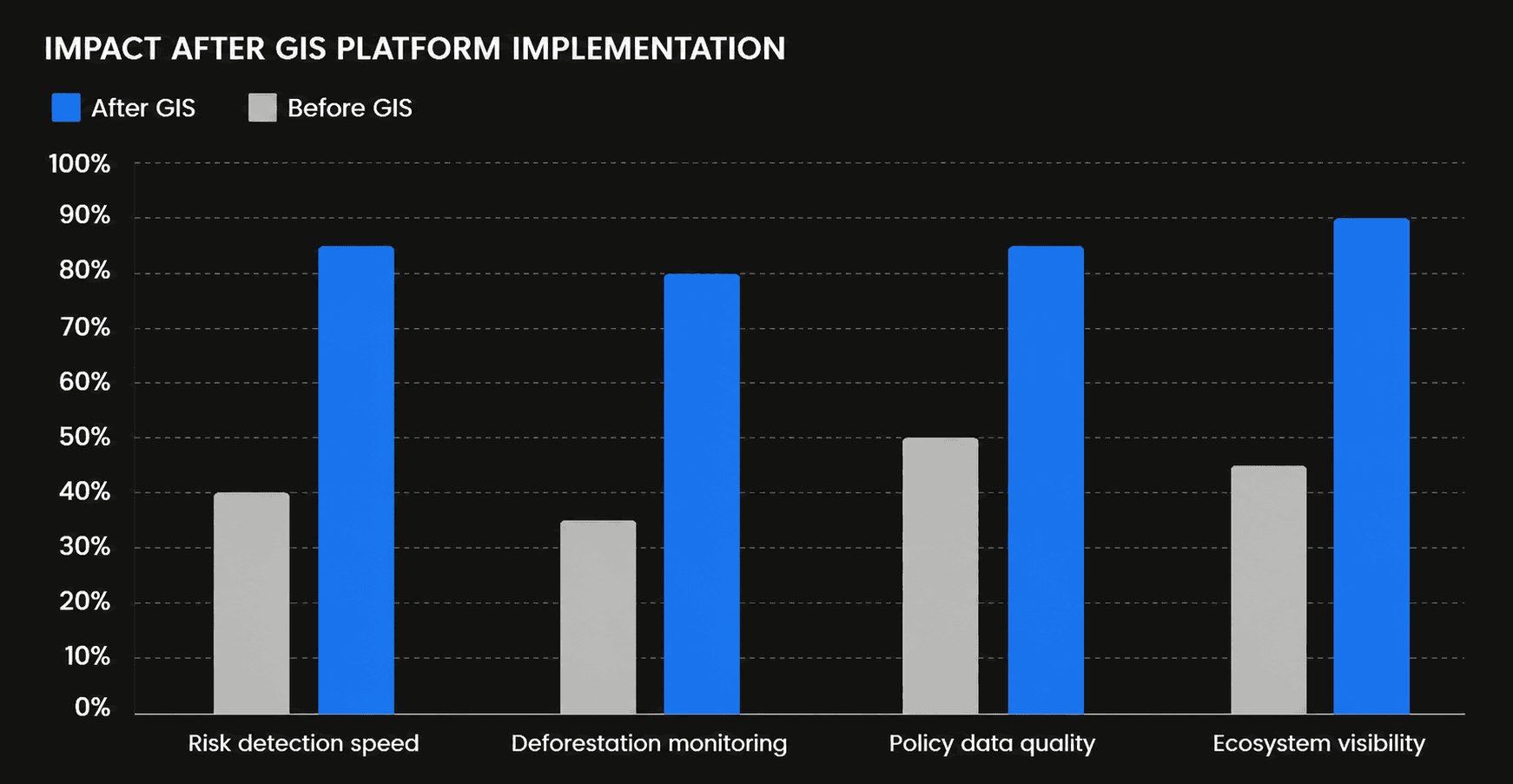
The GIS spatial analytics platform significantly improved the agency's ability to monitor environmental changes and respond to emerging ecological threats. The impact was felt across risk detection, conservation planning, policy development and operational efficiency. Environmental risk assessment processes became faster and more accurate, allowing teams to detect potential threats earlier and intervene before conditions escalated. The predictive wildfire modeling capability represented a significant operational shift, moving the agency from a posture of incident response toward genuine risk prevention.
The agency also gained improved visibility into ecological patterns across its jurisdiction, enabling more effective conservation planning. Teams responsible for wildlife habitat protection and biodiversity monitoring could now track changes over time with spatial precision, identifying areas of concern and building evidence-based cases for conservation investment.
By integrating multiple datasets into a centralized GIS platform, analysts were able to conduct deeper environmental research and develop data-driven policy recommendations. The ability to present spatial evidence through interactive dashboards strengthened the agency's communication with legislative stakeholders and public audiences, supporting greater transparency and accountability in conservation decision-making.
Through the use of GIS spatial services for environmental monitoring, the agency strengthened its ability to protect natural ecosystems and respond to environmental risks with speed, accuracy and confidence. The platform also created a scalable data foundation that can accommodate new monitoring technologies, additional geographic coverage and evolving policy priorities as environmental challenges continue to grow in complexity.
Conclusion
This engagement illustrates how GIS spatial analytics can serve as a transformative capability for government environmental agencies facing the dual pressures of data complexity and ecological urgency. By unifying satellite imagery, climate data, field observations and ecological research into a single spatial platform, the agency moved from fragmented, reactive monitoring to a connected, proactive approach to environmental protection.
The results extend beyond operational efficiency. When environmental analysts can detect wildfire risk weeks earlier, track deforestation in near real-time and present spatial evidence to policymakers through intuitive dashboards, the downstream impact on conservation outcomes is substantial. Ecosystems receive protection sooner, resources are deployed more strategically and policy decisions rest on a stronger evidentiary foundation.
For environmental agencies navigating the growing complexity of climate-driven risk, this case demonstrates that geospatial intelligence is not a supplementary tool. It is central infrastructure for effective, accountable and future-ready environmental governance.