
Data Migration & System Integration
Future-proof your geospatial ecosystem with secure, accurate, and zero-downtime migrations.
Whether you are modernizing legacy GIS, consolidating systems, moving to cloud platforms, or integrating spatial and non-spatial data, our Data Migration & System Integration services ensure your data is clean, connected, compliant, and ready for enterprise operations.
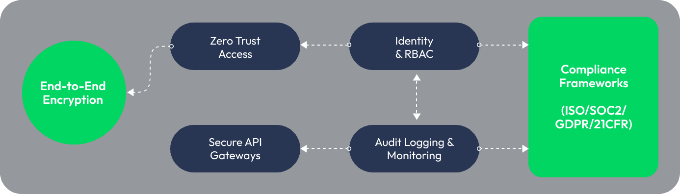
Unified, Secure, and Real-Time GIS Interoperability
We integrate GIS with the enterprise systems that run your operations, ERP, CRM, asset management, SCADA, IoT, billing platforms, and cloud data lakes.
Our integration approach ensures
Bi-directional data flows
Real-time event-driven pipelines
Identity-based access & Zero-Trust security
Harmonized data schemas
High throughput data processing
Security & Compliance Architecture
Moving Legacy Data into Trusted, Enterprise-Ready Systems
With deep experience across Esri, Hexagon, Open Source, Spatial RDBS, and cloud-native platforms, we handle migrations of any complexity.
Our migration platform, NetMapper, enables

Automated extraction from legacy GIS & siloed systems

Rule-based transformation & schema harmonization

Intelligent validations & enrichment

High-volume loading to target platforms

End-to-end auditability
From fragmented GIS to a trusted Geospatial Backbone
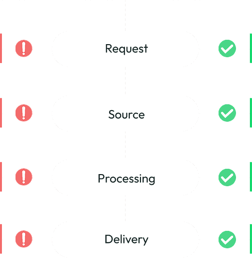
Typical Process
Client initiates a data request
Internal & external data sources
Data extracted, transformed, consolidated
Unified dataset returned to client
Interoperability Workflows
Business and system data intake
Legacy, modern, partner, IoT sources
Data normalized, integrated, streamed
Data delivered to platforms & lakes
Request
Challenge
Client initiates a data request
Solution
Business and system data intake
Source
Challenge
Internal & external data sources
Solution
Legacy, modern, partner, IoT sources
Processing
Challenge
Data extracted, transformed, consolidated
Solution
Data normalized, integrated, streamed
Delivery
Challenge
Unified dataset returned to client
Solution
Data delivered to platforms & lakes
Making GIS data Analysis‑Ready, Model‑Ready, Decision‑Ready


Data cleaning


Attribute corrections


Geometry transformations


Dataset merging


Schema standardization


Enrichment & attribution
Our team ensures the data is analysis-ready, model-ready, and decision-ready.

Assurance at scale: accuracy, completeness, topology safety
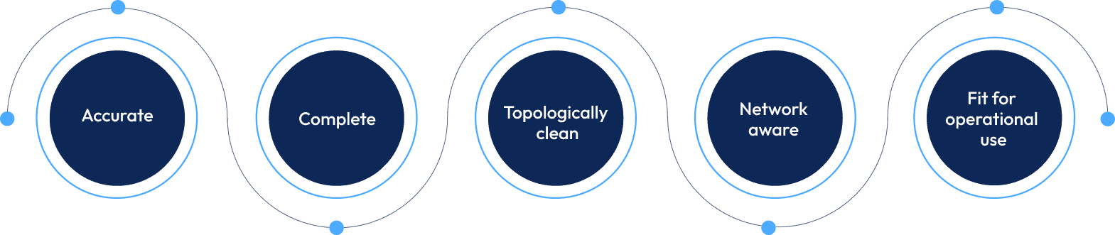
Our QA/ QC experts identify the cascading impact of errors , ensuring data maturity that aligns with engineering, planning, and operational teams.
End-to-End Data Migration Framework
Structured, auditable, and designed to eliminate risk at every stage
01
Know Your Data
02
Data Clean-Up
03
Maintenance & Protection
04
Governance & Reporting
Measurable outcomes, not assumptions
Proven performance across real-world enterprise migrations
100%
Migration completeness, No data left behind
95%
Automated anomaly correction, Clean, standardized data at scale
60%
Reduction in schema fragmentation
40%
Faster QA with drilldown audit trails
99%
Anomaly detection accuracy, Issues flagged before they escalate
100%
Zero-downtime integration
during cutover
These metrics reflect real-world implementations across utilities, telecom, public sector, and infrastructure.
Resource Center
Insights, case studies, and guides to help you maximize your geospatial investments.
Will Data Centres Become the Biggest Bottleneck in AI?
AI demand is driving one of the largest expansions of computing infrastructure in recent history. According to a Reuters report published in July 2026, Hut 8 signed a $9.8 billion lease

Environmental Monitoring and Risk Assessment Using GIS Spatial Services
A government environmental protection agency in North America is responsible for monitoring forests, wildlife habitats, water resources and environmental risks across a large
Start with pgvector: When Enterprise RAG Needs a Dedicated Vector Database
A RAG system can have a powerful LLM and still fail because the retrieval layer brings the wrong context.
Ready for a Clean, Unified, and Future-Proof Geospatial Data Ecosystem?
Let’s simplify your migration journey and modernize your integrations, securely and without downtime.


